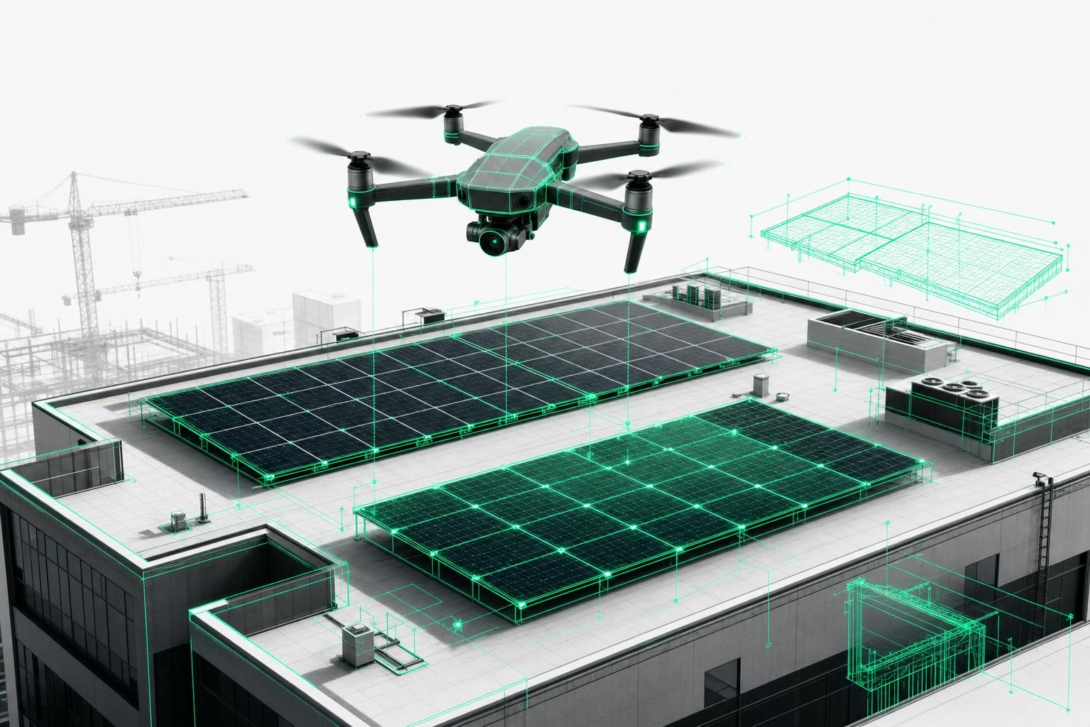
A 3D roof survey with a drone is often seen purely as a tool for preparing quotes - and then quickly forgotten. In practice, however, a single 3D building model can support you throughout the entire lifecycle of a PV installation: from costing and material planning to scaffolding, handover, invoicing, and ongoing maintenance.
This article shows how you, as a solar installer, can use one single drone survey to make every phase of your project more efficient, safer, and more profitable - and the role the Airteam Fusion Platform plays in that process.
Why a 3D roof survey is more than "just" a quoting tool
Many companies currently use drone surveys only at a single point in the process: fly once, calculate the quote, done. That leaves a lot of potential on the table.
With an AI-powered 3D building model, you gain three key advantages across the entire process chain:
- Higher efficiency: fewer site visits, faster decisions, fewer follow-up questions
- More safety: your team stays on the ground while critical roof areas are captured from the air
- A stronger basis for planning: precise areas, real roof structures, and a reliable foundation for structural analysis, layout, scaffolding, and maintenance
Airteam customers save up to 90% of the time required for roof and facade measurements compared to manual surveys - an advantage that extends far beyond the quoting phase.
Safety is also critical: In Germany, around 30-31% of fatal workplace accidents are due to falls, many of them on construction sites and roofs[1]. Every survey you perform with a drone instead of from a ladder reduces this risk.
The five phases of the PV process chain - and how 3D surveys support each one
We will look at five typical phases of a PV project and show how you can use a single drone survey consistently from start to finish.
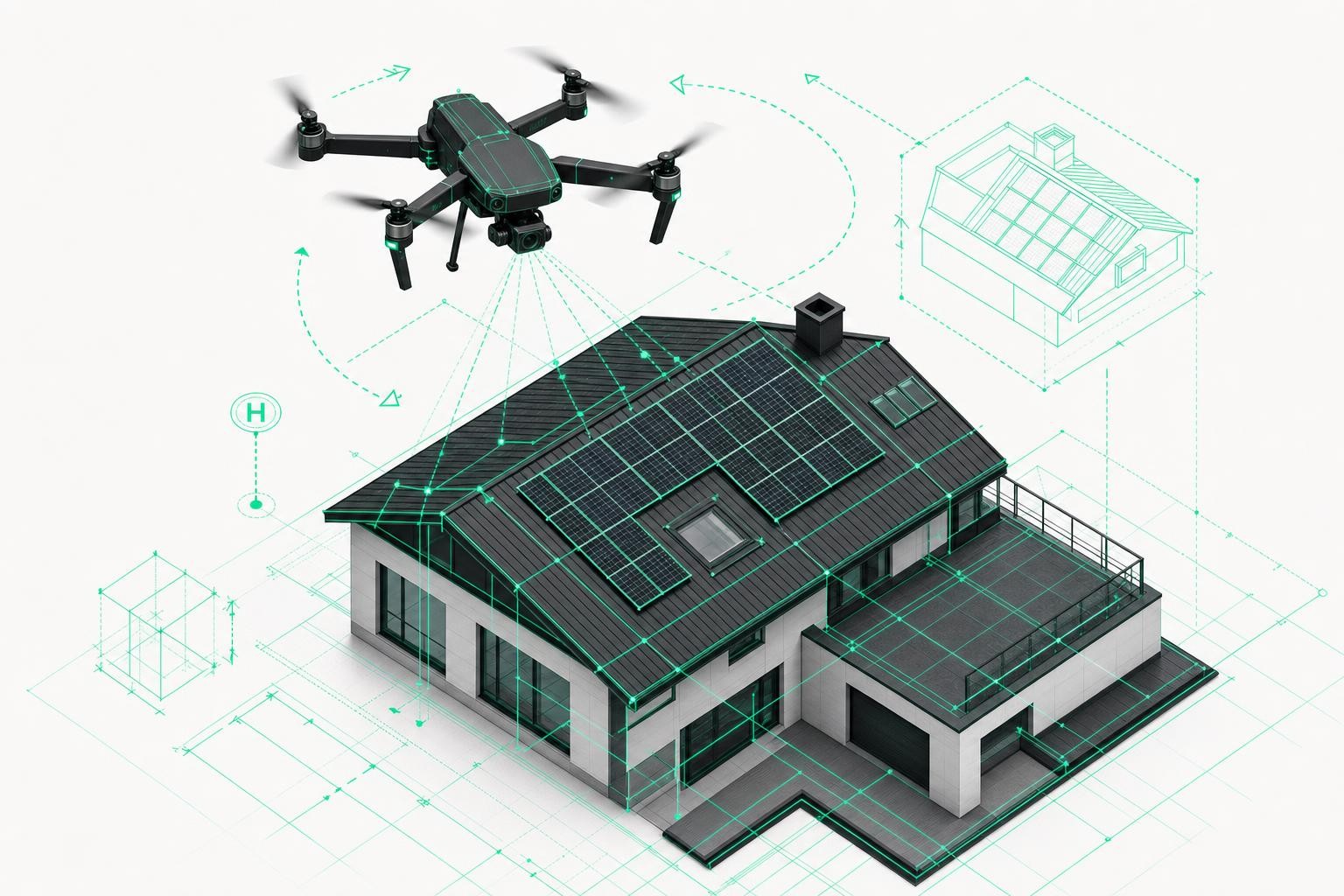
Phase 1: Quoting - calculate faster and win more projects
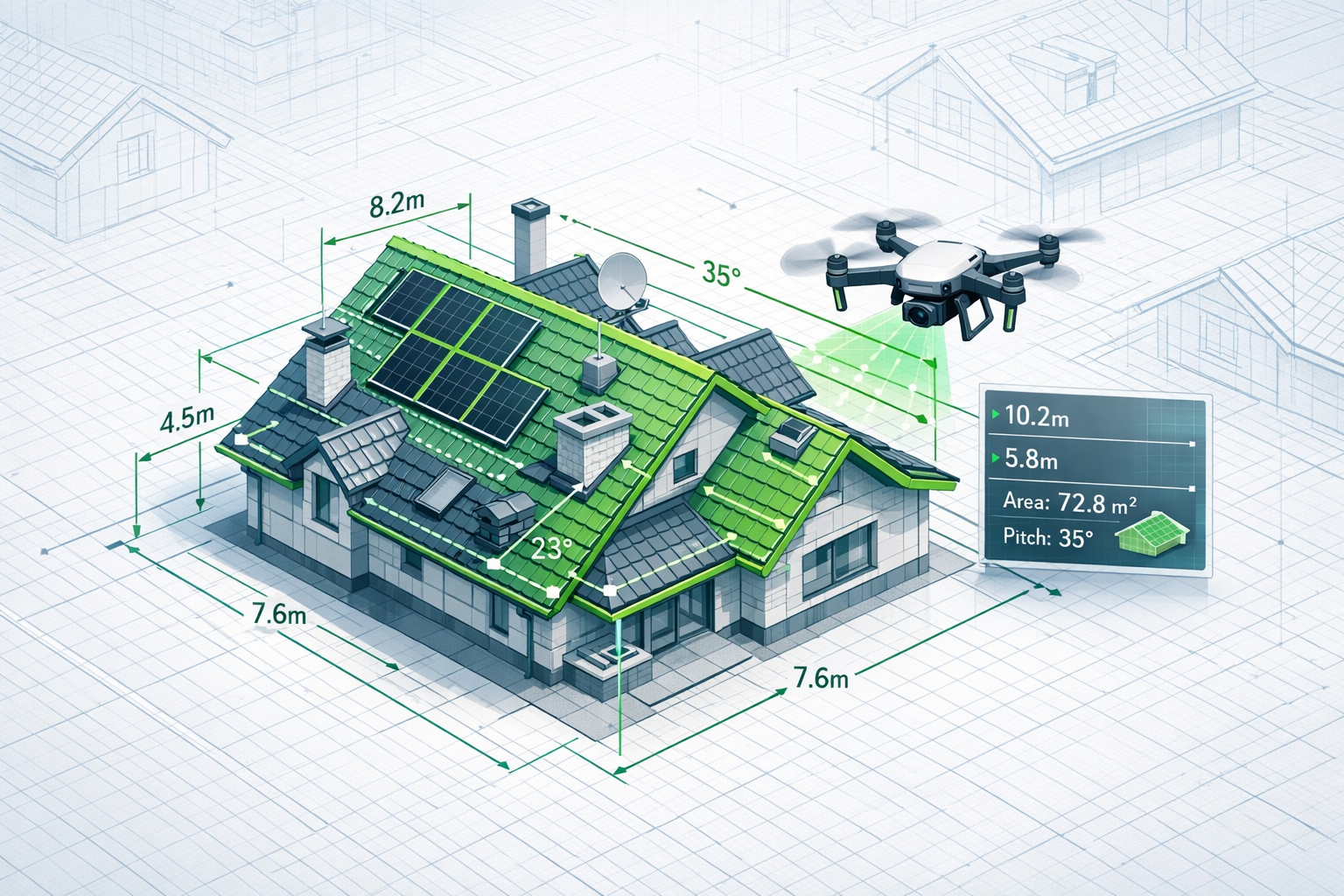
Accurate measurements & complete roof capture
With a drone survey you capture the entire roof:
- All roof surfaces, pitches, and eave heights
- Dormers, chimneys, roof windows, and shading elements
- Attachments, structures, and critical details
The Airteam Fusion Platform automatically converts this into a 3D building model with quality-assured planning data.
The accuracy of Airteam models is up to 99.9%, with a tolerance of 1-3 cm at a flight altitude of 40 m, based on a DIN-compliant specification. The complete 3D model is usually available within 24 hours of the drone flight.
Your benefits in the quoting phase:
- Reliable calculations instead of rough estimates
- Lower safety margins for material and installation times
- Professional visualizations directly from the 3D viewer
A real-world example with a solar installer shows: Using Airteam, the close rate increased by 38%, measurement errors dropped by 92%, and time spent on planning and quotes was reduced by 63%.
Direct integration with PV design software
You can feed your 3D survey data straight into PV design tools:
- Export to PV*SOL, Eturnity, SolarEdge Designer, and others
- Automatic detection of roofs and obstacles
- Fast generation of layout plans
Airteam supports more than 15 export formats, including PV*SOL, Eturnity, AutoCAD, SketchUp, SEMA, and Scaffmax. This eliminates manual redrawing in your software - a major time saver.
Phase 2: Project preparation - materials, scaffolding, logistics at a glance
Once the contract is signed, the same 3D model becomes the control center for your project preparation.
Material ordering & PV layout
- Exact surface measurements for modules, rails, hooks, and fixings
- Consideration of edge clearances, fire safety zones, and escape routes
- Realistic shading analysis based on the actual roof structures
According to Airteam's evaluations, precise 3D data can reduce PV project planning time by up to 50%, depending on the setup, while measurably improving energy yield through optimized module placement.
Scaffolding and crane planning without extra site visits
Scaffolding companies and crane providers can use the same data:
- Exact building heights, widths, and setbacks
- Facade dimensions for scaffolding design
- Panoramic images for crane positioning and access routes
This reduces coordination effort and unnecessary trips to site. Scaffolding contractors can quote based on Airteam reports - without visiting every location beforehand.
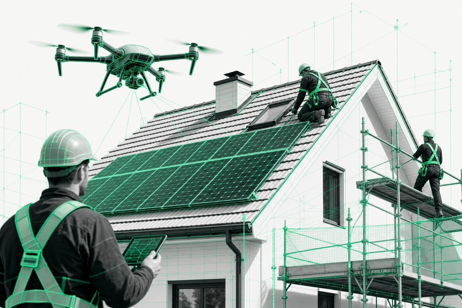
Phase 3: Construction - fewer surprises on site
In many companies, a large screen hangs in the warehouse or meeting room. This is where the 3D roof survey really proves its value during the construction phase.
Benefits at a glance:
- Installation teams can review the roof in the 3D viewer before going on site
- Critical areas (e.g., tight spaces, structures) can be discussed in advance as a team
- Questions can be clarified directly on the model - by phone or via screen sharing
Your outcome:
- Fewer additional trips thanks to precise planning of materials and tools
- Less downtime, as uncertainties can be resolved quickly
- Better schedule adherence due to fewer surprises on site
With a consistent data foundation, all trades work from a reliable single source of truth.
Phase 4: Handover & invoicing - document what was actually built
One major, often overlooked benefit of drone surveys is comprehensive documentation.
Before-and-after documentation as legal proof
- High-resolution aerial images before work begins
- 3D model and detail photos after completion
- Exact traceability of roof condition, any damage, and execution details
For PV projects, Airteam documents every roof tile and every joint in high resolution, with timestamps and georeferencing - enabling clear proof of the roof's condition before installation in the event of a dispute.
Especially for VOB/C-based invoicing, you benefit from:
- Digital quantity takeoffs based on verifiable area and length measurements
- Standardized reports for quotes, variations, and final invoices
Again, the original survey remains your foundation - supplemented by an additional drone flight at completion.
Phase 5: Maintenance & inspection - manage assets efficiently
For housing associations, utilities, or solar installers with maintenance contracts, the combination of 3D models and drone inspections is particularly efficient.
Typical scenarios:
- Annual visual inspections of PV systems across multiple roofs
- Monitoring of roofs with known pre-existing damage
- Documentation after extreme weather (storms, hail)
Instead of driving to each property individually, you can survey multiple roofs per day and evaluate them back in the office. Detail images and 3D models allow you to identify real issues quickly and prioritize maintenance tickets accurately.
Combined with the Airteam Fusion Platform and flat-rate packages, you can plan recurring inspections efficiently - whether for single-family homes, commercial buildings, or entire neighborhoods.
Key metrics at a glance: The added value of 3D roof surveys across the process chain
| Project phase | Typical benefits from 3D surveys | Potential metrics* |
|---|---|---|
| Quoting | Fast, robust calculations, stronger proposals | Up to 90% less measurement time; higher close rate |
| Project preparation | Reliable material, scaffolding, and crane planning | Fewer over-orders and extra trips |
| Construction | Fewer questions, fewer surprises | Reduction in rework and schedule changes |
| Invoicing | Legally robust documentation, clear quantity takeoffs | Up to 0% rework for fully documented projects |
| Maintenance & assets | Efficient service, fast damage prioritization | Multiple roofs per day, evaluation done in the office |
*Metrics vary depending on company size, project type, and software setup.
How Airteam supports you throughout the entire process chain
Airteam has developed its AI-driven cloud software specifically for the needs of roofing, solar, scaffolding, and timber construction companies.
As a solar installer, this gives you:
- Airteam Fusion Platform: automated 3D building modeling from drone imagery, including reports, sections, areas, and various export formats
- DIN-certified precision: Airteam provides DIN-certified accuracy in centimeter-precise models - ideal for VOB/C invoicing and PV structural calculations
- Safety: All measurements are taken from the ground, eliminating the need to measure on the roof itself. The risk of accidents is reduced to almost zero
- Flexible usage: flat rates (Fast/Pro/Max/Ultra Fusion) plus credits to unlock larger areas or specialized planning data such as PV reports, roof or facade reports
- Optional pilots: if you do not have your own drone, you can book certified Airteam pilots to carry out the survey for you
This turns your drone survey into an end-to-end foundation for every project - far more than just a quoting tool.
Conclusion: One survey, five phases of value
For solar installers, a 3D roof survey is no longer a "nice to have" - it is a strategic tool:
- You speed up your quoting phase and improve your close rate.
- You plan materials, scaffolding, and logistics based on reliable data.
- You reduce risks and questions during the construction phase.
- You protect yourself at handover and invoicing with complete documentation.
- You build the foundation for scalable maintenance and asset management.
The key is to use your 3D survey consistently in every phase. With the Airteam Fusion Platform, suitable flat rates, and credits, you can integrate this approach without major training effort - and drive the digital transformation of your business in a targeted way.
Frequently Asked Questions
How much time do I save with a drone survey compared to traditional measuring methods?
With 5-15 minutes of drone flight time, you can replace several hours of measuring work on the roof. Airteam states that you can save up to 90% of the time required for measurements. An additional advantage: fewer follow-up questions and less rework, because everyone works from the same 3D model.
Do I need special CAD skills to use the Airteam Fusion Platform?
No. The platform is designed for trade businesses that work without CAD expertise. You use a web-based viewer, predefined reports, and export interfaces to PV design software.
How safe is working with drones compared to using ladders?
The drone takes over the work at height - your team stays on the ground. Since fall accidents account for a large proportion of fatal accidents in construction, drone-based surveying significantly reduces the risk[1]. Airteam also provides you with C1-certified drones, training, and an optional pilot network.
Is a 3D survey worthwhile even for smaller roofs and single-family homes?
Yes, especially if you complete many projects per year. A standardized digital process saves time every single time you quote, plan, and document a project. With Airteam flat rates, you can create as many 3D models as you like up to a defined roof area and scale efficiently with your project volume.
What do I need to get started with Airteam?
The easiest route: register on the Airteam Fusion Platform, book a starter kit including drone and training, or use the pilot network. You then plan flights in the cloud software, upload your images, and receive your first 3D roof model within a short time - ready to use for quoting, planning, and more.