Refurbishment roofs are rarely "off the shelf": incomplete or outdated plans, intricate roofscapes, historic buildings, and combined measures such as insulation, re-roofing, and solar installation. Anyone relying on estimates or a tape measure risks change orders, material errors, and scheduling chaos.
In this how-to guide, we walk through step by step how a drone-based roof measurement makes refurbishment roofs plannable, costable, and contractually robust - from the first site visit through to PV design.
1. Why refurbishment roofs are barely plannable with traditional surveys
Existing buildings usually come with typical challenges:
- Old or missing plans - do not match the actual as-built condition.
- Hard-to-reach areas - dormers, valleys, extensions, courtyards.
- High safety requirements - accessing the roof involves effort and risk.
- Many stakeholders - roofing contractors, PV designers, scaffolders, energy consultants, housing associations.
Consequences of an inaccurate roof survey for refurbishment:
- Wrong quantities -> material must be reordered or remains unused.
- Structural and insulation concepts do not match the real geometry.
- PV design is based on rough estimates, actual yields deviate.
- Disputes with clients over invoicing and change orders.
Digital roof measurements using drones and AI tackle exactly this: centimetre-accurate data, standards-compliant reports, and complete 3D roof models - with no ladders and no gaps in the as-built information.
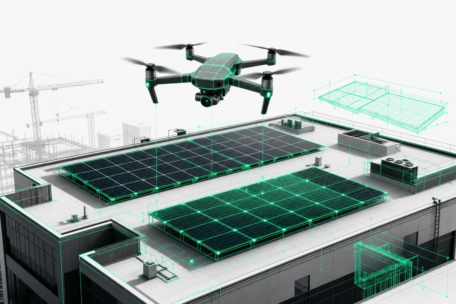
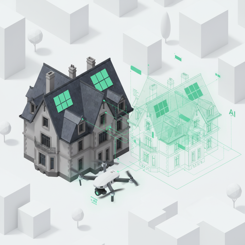
2. What exactly does "drone-based roof measurement" mean?
A drone-based roof measurement is a roof survey carried out with a drone, where:
- The building is flown over in just a few minutes.
- High-resolution, overlapping images are captured.
- An AI uses these images to create a 3D roof model and calculate a complete measurement.
- The results are provided as a measurement report compliant with DIN and VOB/C and in common planning formats.
Modern solutions such as Airteam deliver:
- Centimetre-accurate roof data (typically 1-3 cm tolerance, up to 99.9% accuracy).
- Automatic detection of roof areas, ridges, hips, valleys, dormers, superstructures, and more.
- Standards-compliant preparation - ideal for refurbishment, tendering, and billing.
This gives all project participants access to the same reliable dataset - the foundation for plannable refurbishment roofs.
3. Step by step: How a drone-based roof survey works in refurbishment projects
Step 1: Create the project and define refurbishment objectives
Before the flight you clarify:
- Which measures are planned? (insulation, re-roofing, PV, new dormers, roof windows, additional storeys, etc.)
- Which data is required?
- Areas and lengths for materials and VOB/C-compliant billing
- Geometry and load assumptions for structural analysis
- Detailed roof shapes for PV planning with drones
- Facade dimensions for scaffolding or facade refurbishment
In the Airteam Fusion platform you create the project digitally and select the required services (for example, "roof data" and "facade model").
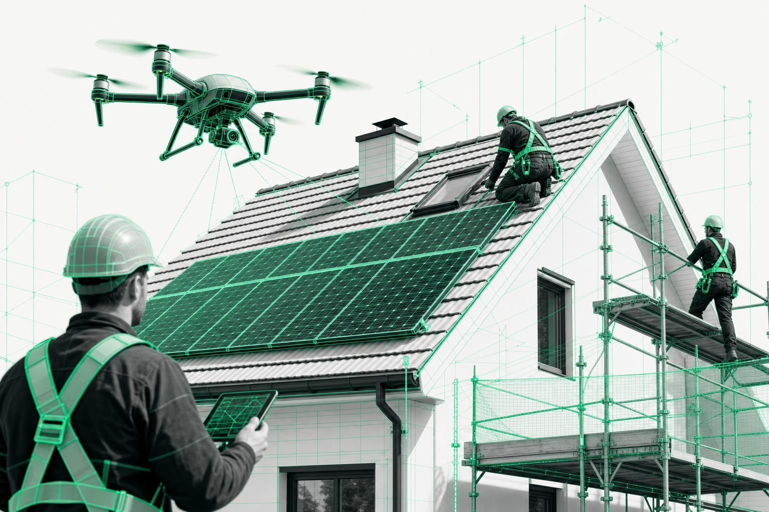
Step 2: Drone flight - surveying existing and historic roofs
Next comes the actual roof survey by drone:
- Flight time: typically around 10 minutes per building.
- The flight can be carried out by your own team (with the Airteam starter kit and training) or by a certified pilot.
- The drone captures even complex existing and historic roofs from all relevant angles - ideal for intricate refurbishment projects.
Important: Your employees remain safely on the ground throughout, which is a major advantage especially on roofs in need of repair.
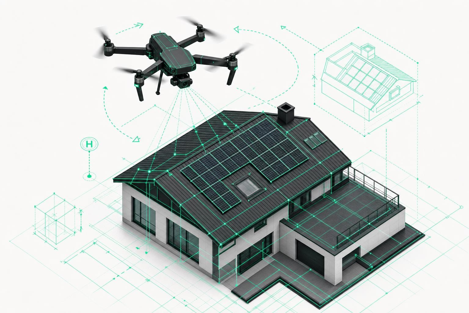
Step 3: Upload and AI evaluation - digital 3D roof measurements
After the flight:
- Upload the images to the browser-based platform via drag and drop.
- The AI processes the data fully automatically:
- creates a 3D point cloud and a simplified 3D roof model
- detects roof areas, slopes, verges, eaves, dormers, chimneys, vents, windows, and more
- calculates all relevant areas, lengths, and angles.
In most cases, the data is available within hours and at most within 24 hours - a huge advantage over manual surveys, which can take days.
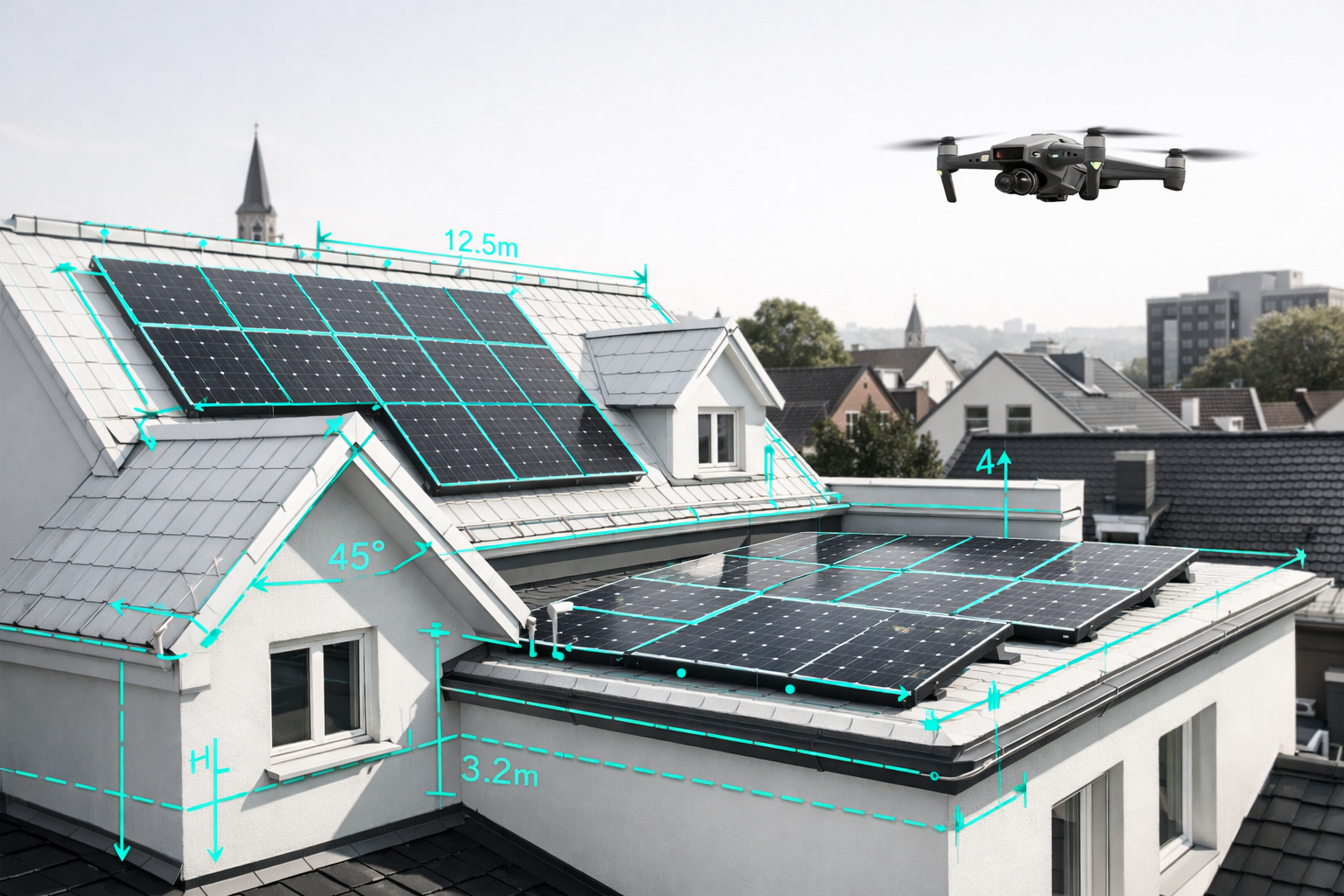
Step 4: Quality control and standards-compliant measurement report
Every model undergoes quality assurance:
- Plausibility checks on all dimensions
- Manual post-processing where necessary for complex structures
- Preparation in a standardised measurement report compliant with DIN and VOB/C, including:
- area and length schedules
- roof data including slopes
- photo documentation of the existing condition
This gives you a legally reliable basis for tenders, quotations, billing, and funding applications.
4. How drone-based roof measurements make refurbishment roofs plannable
4.1 Confident costing: quantities, materials, costs
With centimetre-accurate roof data you can:
- Determine roof areas, rafter lengths, verges, valleys, and hips precisely.
- Realistically calculate insulation volumes, tiles, membranes, and accessories.
- Allow for contingency and offcuts properly - no more rule-of-thumb estimates.
- Reduce change orders because the initial quotation is based on reliable numbers.
Roofing companies report almost 0% rework and significantly more successful bids because their costing is transparent and robust.
4.2 PV integration: PV planning with drones on existing roofs
For combined refurbishment and PV projects, the 3D roof model is the ideal foundation:
- Exact roof slopes and orientations for every partial area.
- Obstacles (chimneys, dormers, roof windows, satellite dishes) are automatically detected and marked in the model.
- Realistic shading analysis in PV tools such as PV*SOL, Eturnity, or SolarEdge Designer thanks to direct data export.
This way, PV planning with drones becomes an integral part of the roof refurbishment - not a late add-on with a high risk of rework.
4.3 Refurbishment planning for historic buildings: truly understanding the existing structure
Roof surveying in historic and existing buildings is particularly critical because:
- old plans are inaccurate,
- additional storeys, dormers, and extensions were often added later,
- there is frequently no up-to-date, complete documentation.
With drone-based roof measurement you obtain:
- a realistic 3D digital twin of the building,
- centimetre-accurate data for structural engineering, insulation, and energy consulting,
- data that can be combined with interior scans for continuous BIM models.
This makes complex refurbishments plannable - from building envelope upgrades to full energy-efficient renovation.
5. Common questions from the field
How accurate are drone-based roof surveys?
Professional providers such as Airteam achieve 1-3 cm accuracy and specify up to 99.9% precision for the measured roof dimensions.
How much time do I save compared to a manual roof survey?
Experience from customer projects shows:
- Up to 90% time savings compared to manual surveying.
- Large roofs with several thousand square metres can be fully captured in under an hour.
Are the digital roof measurements compliant with DIN and VOB/C?
Yes, Airteam prepares the data as a measurement report compliant with DIN and VOB/C - including all areas and lengths for legally secure billing and documentation.
Can I import the data into my existing planning software?
Yes. The digital roof measurements can be exported into the following formats and tools, for example:
- PV planning: PV*SOL, Eturnity, SolarEdge Designer, PVcase
- Roof and timber construction: SEMA, MF Dach
- CAD: DXF/DWG, SketchUp, other 3D formats
- Scaffolding design: Scaffmax
This allows you to integrate the drone-based roof measurement seamlessly into your existing workflows.
6. How to get started with drone-based roof measurement in your business
For roofers, solar installers, carpenters, and housing companies there are two proven ways to get started:
-
Pilot projects with a service provider
- Commission simple test projects
- Test internal processes and interfaces
- Evaluate profitability and time savings in your day-to-day work
-
Own drone plus flat-rate model
- for example, Airteam starter kit including drone, training, and support
- Employees are ready to fly within a single day of training
- Scalable flat rates for many projects per month
Companies with many refurbishment and PV projects benefit the most: more surveys in less time, less rework, less risk - and refurbishment roofs that finally become truly plannable.
Conclusion: Drone-based roof measurement makes refurbishment roofs predictable and costable
A drone-based roof measurement turns uncertain existing roofs into a precise digital dataset:
- Centimetre-accurate roof data instead of estimates
- Digital roof measurements as a 3D model and DIN-compliant report
- Roof survey for refurbishment, PV, scaffolding, and energy consulting from a single source
- Up to 90% time savings and significantly fewer planning errors
Anyone planning complex refurbishment roofs, historic buildings, and combined roof/PV projects today can hardly avoid roof surveying with drones.
With providers like Airteam, any roof can be turned into a plannable refurbishment project within a few hours - and risky quotations become carefully costed, profitable construction sites.